In addition to random generation of
NPCs,
monsters, and
objects found in dungeons, the quickie dice tool has a couple lists dedicated to describing geographical landmarks or regions, wild or inhabited. This can be used to roll up a quick description of some unmapped, legendary land when characters find maps or scrolls, or as a tool for mapping out a region hex by hex, either during prep or during play.
The geographical rolls are divided into two basic types: terrain and territory. Terrain rolls describe the physical characteristics of a location' the procedure is similar to rolls for basic beasts, but using a list of Land features or Water features in place of the Beast list. The horizontal position sets the color of the feature, so that you can have red deserts, blue canyons, or a black lake. For more exotic geographical features, you can substitute Material for Color, or perhaps a mix of the two; if the d6 roll is even use color, and if it is odd, use material. Keep in mind that the exotic option has the potential to make really weird geographical features; a hill of glass is pretty unusual, but a glacier of flesh is even more so. You may wish to limit such exotic features to limited regions.
The d6 roll can also be used to set the rough size of the geographical feature. In general, this means that if you are rolling for the contents of a single hex, the default size of the feature is also one hex, on whatever scale you happen to be using. The extreme lowest and highest results on the d6 change the size; on a 1, the feature is smaller than normal, with the bulk of the hex being a different geographical type (rolled separately, or based on bordering geography;) on a 6, the feature is larger than normal, either twice as wide and three times as long, or roll 2d6 for the length in hexes for each dimension, whichever seems more appropriate. If you want to combine the size roll with the even/odd rule given above for ordinary versus exotic geography, note that all features smaller than one hex will be exotic and all multi-hex features will just be standard features in various colors. This helps avoid mountain ranges made of flesh or glass, in case you don't want exotic geography to dominate the map.
Alternative dice rolls are possible. By default, you pick whether a feature is land or water and use the appropriate list. You can, however, roll a d4, with a 50/50 chance for either list, or only use the 50/50 roll for the first hex of a fresh hex map; other hexes would be weighted towards the same general geographical type as their bordering hexes. One approach:
1-2 Same type as border hex, or majority of border hexes.
3 Same type as border hex, but different Material instead of Color
4 Opposite type (coastline or river bank,) different Color
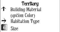
In contrast to the purely physical aspects of the terrain roll, the territory roll describes how humans (or the dominant intelligent race) use the region. You won't roll this for every hex on a map; the territory roll is used for urban hexes or their bordering hexes, with everything beyond that either uninhabited wilderness or another settled area. The vertical position of the die determines how the territory is used; some of the results, such as a forbidden zone, ruins, or a battlefield, won't normally have a population, and nomad lands will be very sparsely populated. The horizontal position can provide a quick guide to what the buildings, if any, look like, using either the material or the color. The result of the d6 roll is a rough population size, with 1 (small) indicating a hermit or very small campsite and a 6 (large) indicating a city. It's possible to switch this to a d8, using the 8 for cities, so that you can roll territory and terrain simultaneously. A more elaborate method would be to roll three dice: a d6 for terrain and size, a d8 for territory type and population size, and a d4 to determine whether the area is mundane (use colors) or exotic (use materials,) as described earlier. The position of the d4 can add a little more description to the roll; for example, it could determine the dominant class or inhabitant type, or the primary economic activity. It could also be used for current events, but there will be more on that in a future post.


No comments:
Post a Comment